Category Archives: Geology

Looking Back, Looking Forward

“The Badlands”
Wall, South Dakota

I’ve been laid up for the last couple of weeks and have not been able to get out and do any photographing. As such, I have been catching up on various photography topics. Jason O’Dell just put out a webcast on the Badlands that caught my eye. Jason, thanks for the stimulus. I was there for just a few hours as I drove across country from Philadelphia to Washighton. The day wasn’t the best for photography, but I was able to come up with a few that had potential. My visit was more of a scouting trip, hopefully for a return visit when I can spend the time to explore. I look back to my short visit. I look forward to when I will return.
Related Images:

Golden Hour

Selah Ridge Golden Hour”
Heatherwood Spring

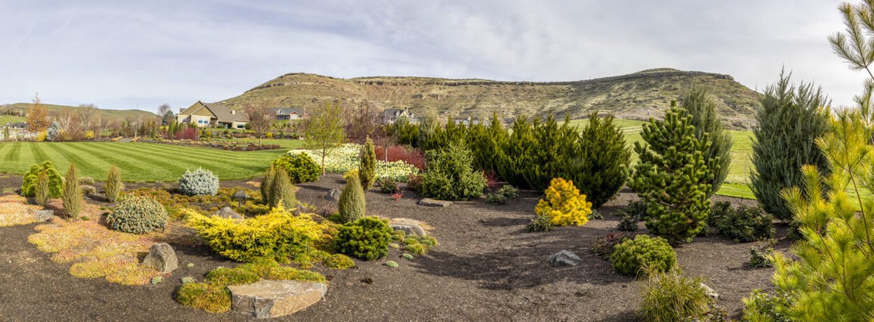
This image was also taken from our view point shown in my 29 April post. From our “Perch” I look up and see history in front of me. Selah Ridge is part of the Yakima Folds running East and West. The rock outcroppings are part of the Columbia Basin basalt flows which occurred around 18 million years ago. Beneath the basalt there are layers of sandstone that once were part of the Pacific Ocean. The brown structure in the lower right is a piece of more recent history. It is part of the Naches-Selah irrigation canal built in the 1890’s. It still has a few years left until it will be torn down and replaced with a “modern” underground pipe. I will hate to see it go!

The day I created this image was a very unusual afternoon. It had been dark and cloudy for most of the day. Then around 5:00 PM the sun broke out and lit up the ridge in a golden orange-brown. The contrast between the warm orange ridge and the dark blue sky was breathtaking. There is always something interesting going on here at Heatherwood.

Related Images:

New Path to More Exploration

“On the Way to the Ridge”
Selah Ridge, Washington

During my walk to the top of the cherry orchard I found a new way to get up to the top of Selah Ridge that overlooks the hillside where we live. There are so many places around our neighborhood to explore. The trek to the top of the ridge from here will be one that I plan to wander and explore.

Looking at this line of basalt rock, I ask myself how this remnant of a lava flow got way up here. Beneath this level of basalt lay strata of limestone-type sediments from an ancient sea bed. How did a sea bed get up here? Piecing the little that I know of the geologic history of the area, the following is what I think happened: First, this area at one time was under the Pacific Ocean. Then the volcanic Cascade Mountains were formed which separated Eastern Washington from the coastal plain. Later, the Eastern Washington, Eastern Oregon, Southern Idaho basalt flows covered what is now the Columbia Basin. Then the moving continental plates slowly forced up the Yakima Folds creating a line of ridges across south central Washington. We live at the base of one of these ridges.

Related Images:

Navaho Dome

Navaho Dome
Capitol Reef National Park, Utah

Capitol Reef National Park is full of unusual forms, outcroppings, ridges, valleys, and canyons. Everywhere I turned, I saw a different formation. Questions flashed across my mind. How were they formed in the first place? When were they created? What was the landscape like at the time of the creation? What was the driving natural force that changed the landscape? What forces caused the erosion to occur in a specific way? Why are there different colors and tones? What are the legends that surround the formation’s history?

Does Navaho Dome reflect the lined face fo wisdom or the peaks and swirls of child’s play? Maybe it is both …


Related Images:

Mid-Day Shadows

Bullfrog Road Near Capitol Reef

On my last day at Capitol Reef I decided to just drive around and scout some of the areas for a future trip. It was mid-day when I saw some interesting shadows on these rock protrusions. The scene looked pretty flat in color. My mind turned black and white. I like clouds and shadows. Here were both.

Related Images:

Crooked River

Crooked River
Smith Rocks State Park, Oregon

On another adventure earlier this spring, we went to Smith Rocks State Park along Highway 97 in Oregon. It a beautiful spring day during local school’s spring break. There was a huge crowd with the same idea as we had to soak up the rays and explore. We took a casual walk along the gorge rim. Others were hiking the steep trails and climbing the shear faces of Smith Rocks (way outside of our physical condition or skill level). It was a great day!

Related Images:

A Beautiful Spring Day

Palouse River Canyon Below the Falls
Eastern Washington

Memorial Day was a beautiful Spring day! We woke up to a beautiful morning full of sunshine. It was time for a road trip! We decided to drive to the Palouse and visit Palouse Falls. Three hours later we were waiting in line to enter the Palouse Falls State Park. Many others had the same idea as we did. The drive and wait were worth it.

This image is taken from above the Palouse River just below the Palouse Falls. Recent rain created the green foliage on the plateau and canyon walls. Normally the scenery is pretty brown. The sky was covered by a patchwork of puffy white clouds. The scene was a a gift!

Related Images:

Can You Imagine …

Palouse Falls , Eastern Washington

Can you imagine these falls during the Ice Age Missoula Floods?  Water was rushing over the top flat rim of the plateau at 70 miles per hour!  The existing falls is but a small trickle of what was.

The amazing geological history of Eastern Washington continues to fascinate me. The current falls are 187 feet tall. The Ice Age Flood falls were about twice in height. Basalt on the canyon walls was created by a series of lava flows between 15 & 18 million years ago. The Missoula Floods creating the canyon occurred 12 to 15 thousand years ago (just a spec of time in our geologic history).

Related Images:

The Castle of Capitol Reef

“The Castle”
Capitol Reef National Park, Utah

This was my first stop at Capitol Reef National Park following my stop at the Visitor’s Center. It was mid-day, the sun was bright, and there were no clouds. So what … I started thinking black and white from the start. I walked around until I was able to frame “The Castle” with the two trees.

To me “The Castle” really did look like a castle overlooking the valley below. It was a good way to start my exploration of Capitol Reef National Park.

Related Images:

Temple of the Moon

Temple of the Moon
Capitol Reef National Park, Uta
h

Following yesterday’s post, this image is the Temple of the Moon. Looking at both of these “Temples” in the valley and the heavily eroded hill sides on the perimeter makes me wish that a time-lapse camera could have caught the changes over the eons of time. How interesting it would be to watch nature’s elements carve out these natural structures.

As reference, the image of the Temple of the Moon and rising moon on 28 March was taken from the perspective of the small peak on the left.

Related Images: