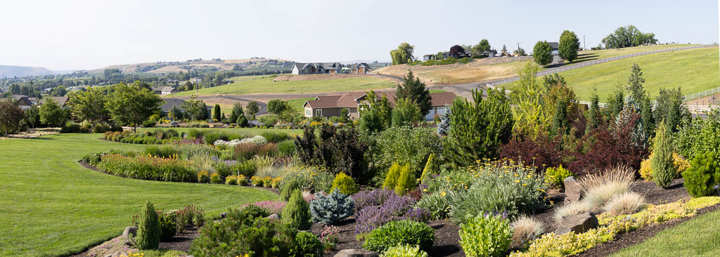
Drumheller Channels Pano

Drumheller Channels – Othello, Washington

This image is a hand-held pano taken above the Goose Lake trail head at the northern part of the Drumheller Channels reserve, just below O’Sullivan Dam.  This was our final stop on our Sandhill Crane photo shoot.  We took a leisurely hike (walk) to cap off a great trip.  Spring is a beautiful time to visit the Channels.  I was hoping for some big white puffy clouds.  But it just did not happen this trip.  I will return …

Related Images:

Sometimes You Get Lucky

Scootney Reservoir Sunset – Othello, WA

After a chilly late afternoon / early evening Sandhill Crane photography shoot, we were looking for a rest area.  The closest one was at Scootney Park.  As we drove down to the lake, the sun had just gone down below the western hills.  The red, orange, and pink colors covered the sky and reflected over the lake.  The rest stop had to be delayed for a while while we captured the beautiful sunset.  We sure got lucky!

Related Images:

More Ice Age Geology – Corfu Landslide

Corfu Landslide – Saddle Mountains, Central Washington

This image was taken from  Lower Crab Creek Road.  It is a small section of the Corfu Landslide. Lower Crab creek is in the foreground. This part of the landslide was probably post Missoula Floods.  It looked like the rocks at the base were not eroded, hence it probably occurred following the last floods.  The land slide extends upward to the Saddle Mountains crest.  A couple of weeks prior to taking this image,  I was at the crest of the Mountain looking down.  Refer to my post of 27 March.

Related Images:

Abstract Fun

Colorado Blue Spruce Abstract 1

Sometimes it is just fun to play around with images.  I knew that I would use various ways of post processing when I first took the image.  Here is one version.  Playing around a little more, I came up with the following abstract :

Colorado Blue Spruce Abstract 2

Related Images:

Head On

Colorado Blue Spruce Tip – New Growth

As I was walking around my yard, I was just looking for images to pop into my sight.  I have photographed new growth on evergreens more times than I can imagine.  However, I have never made an image on new growth taken from a head on perspective. A tip of new growth from a Colorado Blue Spruce just jumped out in front of my eyes. So I looked around more to try to get one that was the most symmetrical.  My mind started to think what I could do with this from an abstract point of view.  I plan to apply some creative alternatives in a future post.

Like my friend John Barclay (www.johnbarclayphotography.com) emphasizes.  Do not force a photograph, let the image come to you.  This one did …

Related Images:

A Beautiful Morning

Small Lake in Othello Channels

After a great photo shoot of Sandhill Cranes in the early morning, we decided to take a drive on back roads and look for more cranes in a different direction.  We saw this little lake along side the road and just pulled off to do a little exploring.  It was such a beautiful morning and such a picturesque little scene.  I just couldn’t help but to stop and snap a postcard.  We didn’t find any more cranes … but we saw some nice scenery.

Related Images:

Drumheller Channels: Missing a Tooth

Drumheller Channels – Othello, WA

The first thing I thought of when I looked up and saw this section of columnar basalt was that it was missing a tooth.  Columnar basalt is very susceptible to water erosion because of its many fissures.  The raging water of the Missoula Floods easily plucked the columns from their path.

Related Images:

Amazing What Water Can Do

Large Pothole – Drumheller Channels

Water did this!  During the Missoula Floods water rushed through Drumheller Channels at about 55 miles per hour.  The water level was about 200 feet above the mesa on the upper right  corner of the photo.  Through the Drumheller Channels the water followed multiple channels.  Turbulent circular, tornado like, flows cut potholes throughout the area.  This one is unique due to the outcropping in the “eye” of the swirl.

A short walk on the Upper Goose Lake trail will bring you to this amazing phenomenon.  The uniqueness of this area continues to amaze me.


Related Images:

Drumheller Channels Overlook

Drumheller Channels Overlook

It is hard to comprehend how enormous the Missoula Ice Age Floods were.  The edge of the bluff in the top left hand corner is approximately 200 feet high.  The water level during the Missoula Floods was about 200 feet above the top of the mesa.  The distance across the Drumheller Channels was 8-11 miles wide.  The water is estimated to have moved through here at 50+ miles/hour.  The landscape left behind is amazing.  My mind wanders about contemplating what it must have been like.

This image was taken at the overlook off the main road running through the reserve.

Related Images: